Authors: Brishan Kalyan, Levis Sirikwa, Eligio Maure
4.6. Overview of data products in ocean colour#
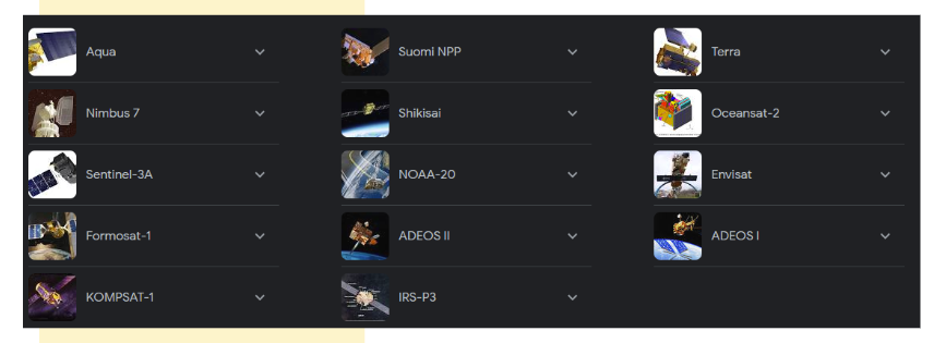
Ocean colour data is gathered by the various satellites (Figure 4.9) and stored as raw data (volts) that are processed (Level 0 - 4) to produce products that can aid in sustainable management by answering scientific and societal questions (Figure 4.4 and Figure 4.9).

Fig. 4.9 Ocean colour satellites. A few active ocean colour satellites that are orbiting the Earth and gathering information.#
4.6.1. File formats#
Data types and formats have changed over the years. However, standardisations and conventions have been used across the various data providers (space agencies / private entities) to produce harmonised data and metadata outputs. A summary of NASA’s Earth Science Data and Information System Standards Office standards and conventions can be found here. The main file format used across ocean data is netCDF4.
NetCDF (Network Common Data Form) is a set of software libraries and machine-independent data formats that support the creation, access, and sharing of array-oriented scientific data (NetCDF) . HDF (Hierarchical Data Format) is a physical file format for storing scientific data and a collection of utilities and applications for manipulating, viewing, and analysing data in HDF files (HDF).
NetCDF is the combination of netCDF4 and HDF5 providing interoperability among scientific data representations and integration of observations and numerical model outputs. The goal of netCDF4 is to make netCDF more suitable for high-performance computing and large datasets, and to provide a simple high-level application programming interface (API) for HDF. The main reasons as to why space agencies like NASA use the netCDF4/HDF5 file format can be found here.
4.6.2. Data processing levels#
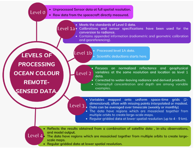
Remote sensed data is computationally processed across various levels (0 - 4) to allow for the creation of different products for end-user utilisation. Figure 4.10 simplifies the levels of processing across ocean colour remote sensed data.

Fig. 4.10 Processing levels of satellite data to provide end-user products for various applications.#
4.6.3. Data Providers#
There are many free and open data providers (space agencies/ private entities) from where ocean colour data can be retrieved. The National Aeronautics and Space Administration (NASA) provides different ways to browse, order and download ocean colour data. NASA’s Worldview allows an interactive visualisation and download capability for both historic and recent imagery layers that are updated daily and made available within hours of observation. The Worldview platform, however, is not a dedicated ocean colour dissemination portal. The Ocean Biology Processing Group (OBPG) serves as the Distributed Active Archive Center (DAAC) for all Ocean Biology (OB) data. The OB.DAAC provides interfaces for (i) searching, (ii) browsing, (iii) ordering and (iv) downloading ocean colour data at different data levels. OB.DAAC data are free and open to the public, but downloading of any products requires registration. New users should obtain an account on the Earthdata user registration page prior to being able to download the data. OB.DAAC data are also hosted in NASA’s Earth Observing System Data and Information System (EOSDIS). NASA’s Common Metadata Repository (CMR) provides a unified repository for Earth science metadata to facilitate access to Earth Observation data through programmatic interfaces. Examples on how to search data using CMR will be introduced below.
In this e-manual we focus the examples on data by NASA and JAXA (Japan Aerospace eXploration Agency). We briefly cover the Globe Portal System (G-Portal), a portal with similar capabilities of NASA’s OceanColor Web. Similarly, users should obtain credentials prior to being able to download JAXA’s EO data. Like the CMR, JAXA also provides a way for metadata search denoted CSW (G-Portal User’s manual, accessed 11 October 2022).
4.6.3.1. Why NASA’s OB.DAAC and JAXA’s G-Portal?#
We will extensively explain how to obtain ocean colour data from the OB.DAAC and G-Portal since they are the main data providers used during the training that inspired the creation of this e-manual. NASA’s OB.DAAC provides most of the ocean colour data that extends beyond NASA’s sensors, such as GOCI, MERIS, Sentinel 3A and 3B, etc. JAXA’s G-portal provides high spatial resolution data that enables one to obtain detailed information on coastal areas.
However, there are many other ocean colour data providers worth of mention. The GlobColour Project is a web portal serving as the European Node for Global Ocean Colour. It provides scientists with a long time series of consistently calibrated global ocean colour information. The Copernicus Marine Service provides free and open ocean data across the global ocean and across many ocean disciplines. The OceanColour - CCI is an ocean colour web portal that provides satellite observations of ocean colour, focusing on the Ocean Colour Climate Change Initiative project, it has browsing, downloading, and analysis capabilities.
